By Kelly Davila and Mark Abraham
Scroll down to view maps and charts.
Census data highlight increasing population, diversity in New Haven
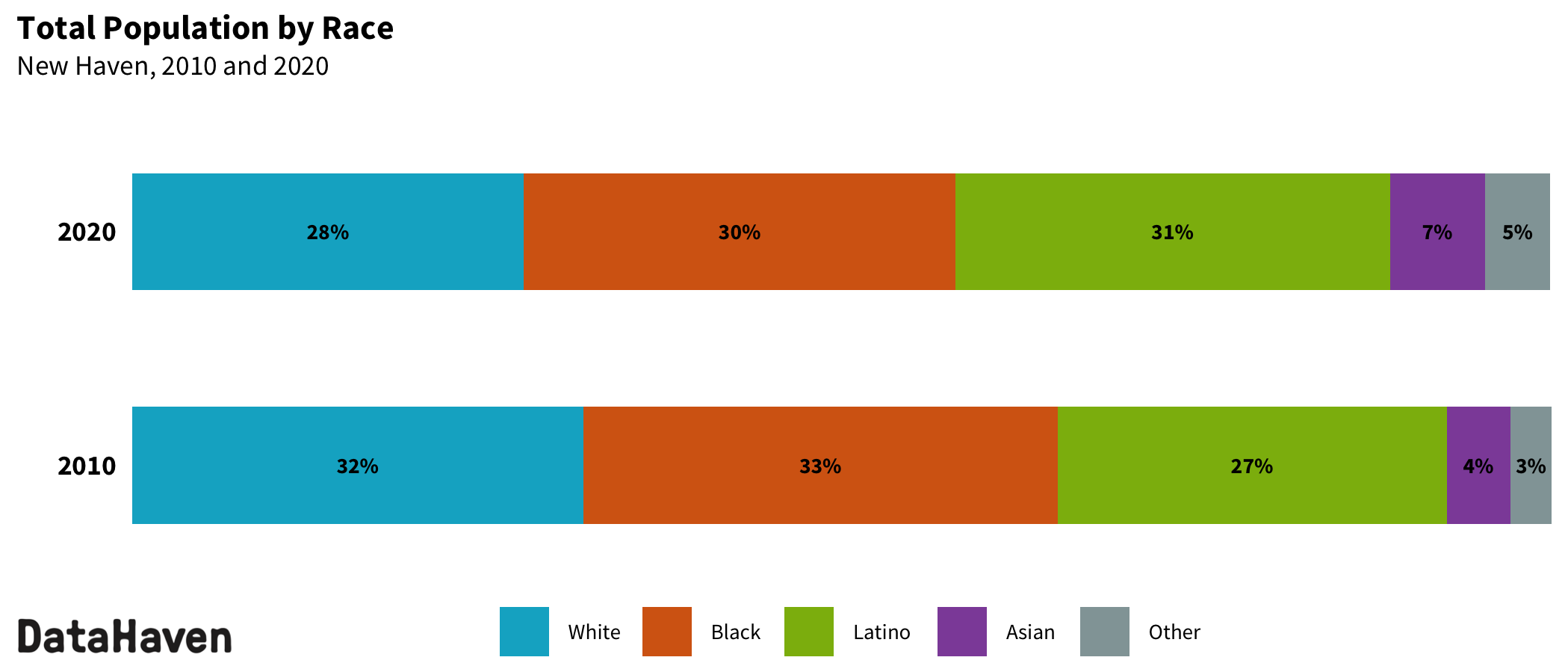
The Latino community is now the largest demographic in New Haven, comprising 31 percent of the city’s population. Across the nation, Latinos are the fastest growing ethnic group, according to brand-new Census data released in August. Within New Haven, the Latino community has grown by 5,477 people since 2010.
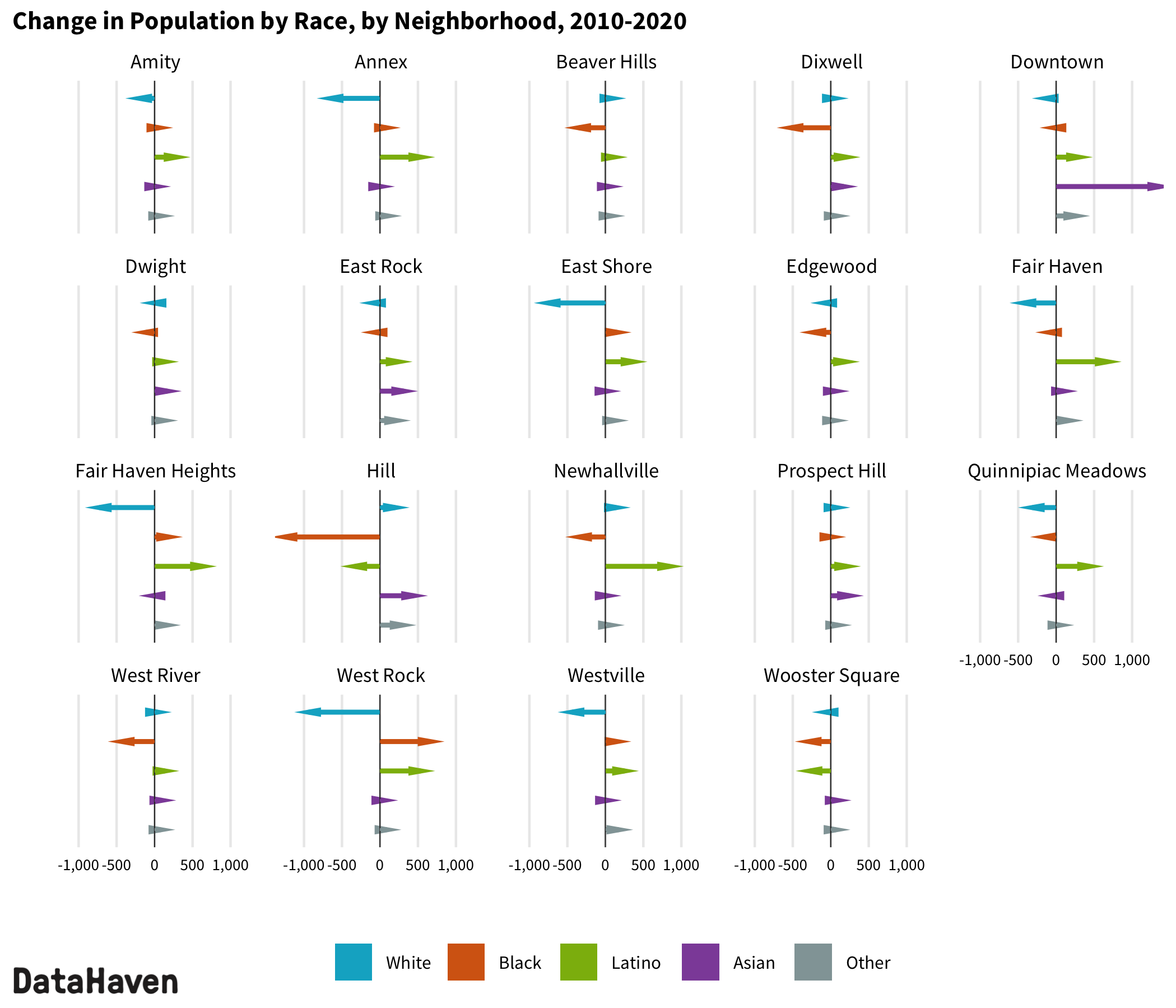
City neighborhoods where the Latino population rose by more than 500 residents included Newhallville (increase of 845), Fair Haven (increase of 673), Fair Haven Heights (increase of 631), the Annex (increase of 538), and West Rock (increase of 538).
A DataHaven analysis of local trends offers a closer look at how neighborhood demographics have shifted in the past decade. The new data offer the most accurate count of the population since 2010.
New Haven’s white population shrank from 32 percent to 28 percent and is now the smallest of the three predominant racial groups in the city. Meanwhile, the city’s Black population declined from 33 percent in 2010 to 30 percent in 2020. In 2010, the Asian population represented 4 percent of the city’s population, but this rose to 7 percent in 2020, an increase of 3,180 residents.
Population Change in New Haven
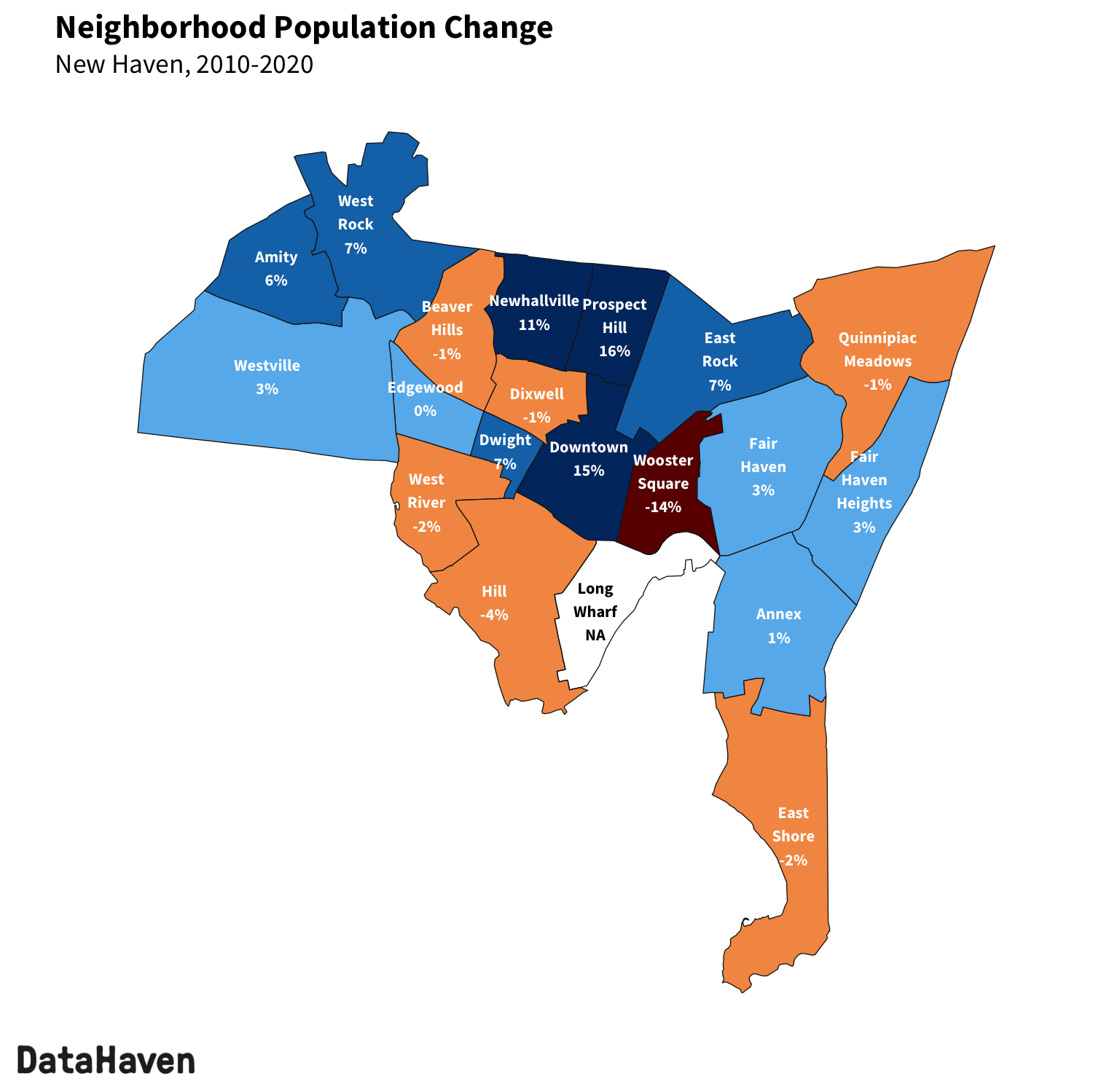
Between 2010 and 2020, New Haven’s total population increased by 4,244 people, from 129,779 to 134,023 (a 3 percent increase, compared to the 1 percent increase statewide). This growth was in line with a statewide trend in which the ten largest cities collectively added 37,109 residents while the other 159 towns declined in population by 5,262. In New Haven, the adult population grew by 4,813 to 105,010 (a 5 percent increase, compared to the 4 percent increase statewide) while the child population declined by 569 to 29,013 (a 2 percent decrease, compared to the much larger 10 percent decrease statewide).
However, population growth was uneven across the city’s neighborhoods.
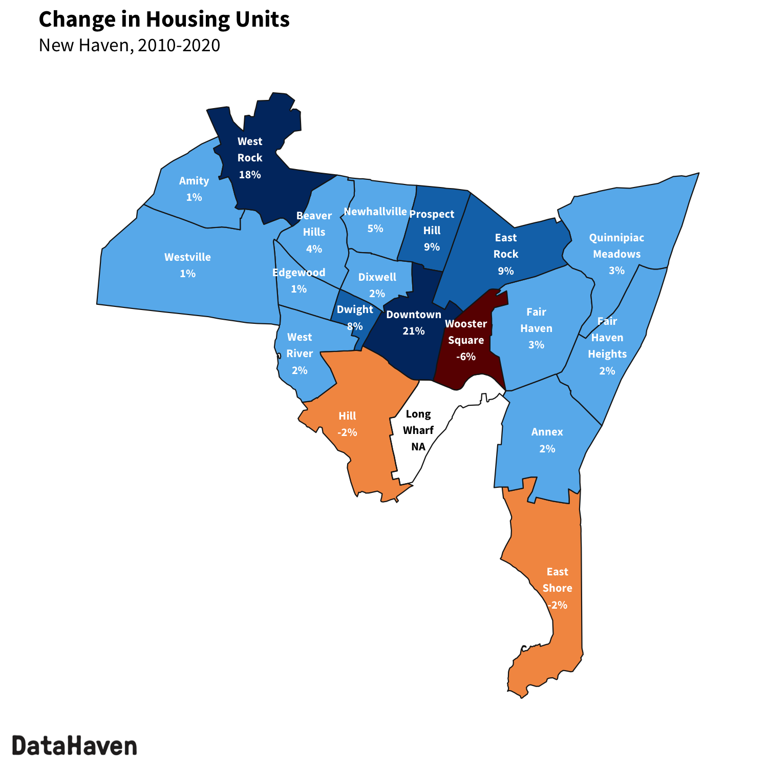
Downtown added the most people, with 1,796 new residents—a 15 percent increase from 2010. Downtown registered 1,046 new housing units in the past decade, many of them built within just the past few years—a trend which seems to be accelerating.
The population also increased in the two neighborhoods that encompass the campus of Southern Connecticut State University, which added new housing over the past decade. Due to changes to the census boundaries between West Rock and Beaver Hills, it may be helpful to think of them as a combined area when comparing 2020 population and housing counts to 2010. This is the only location in the city where neighborhood boundaries were redrawn slightly in a way that may noticeably affect population counts.
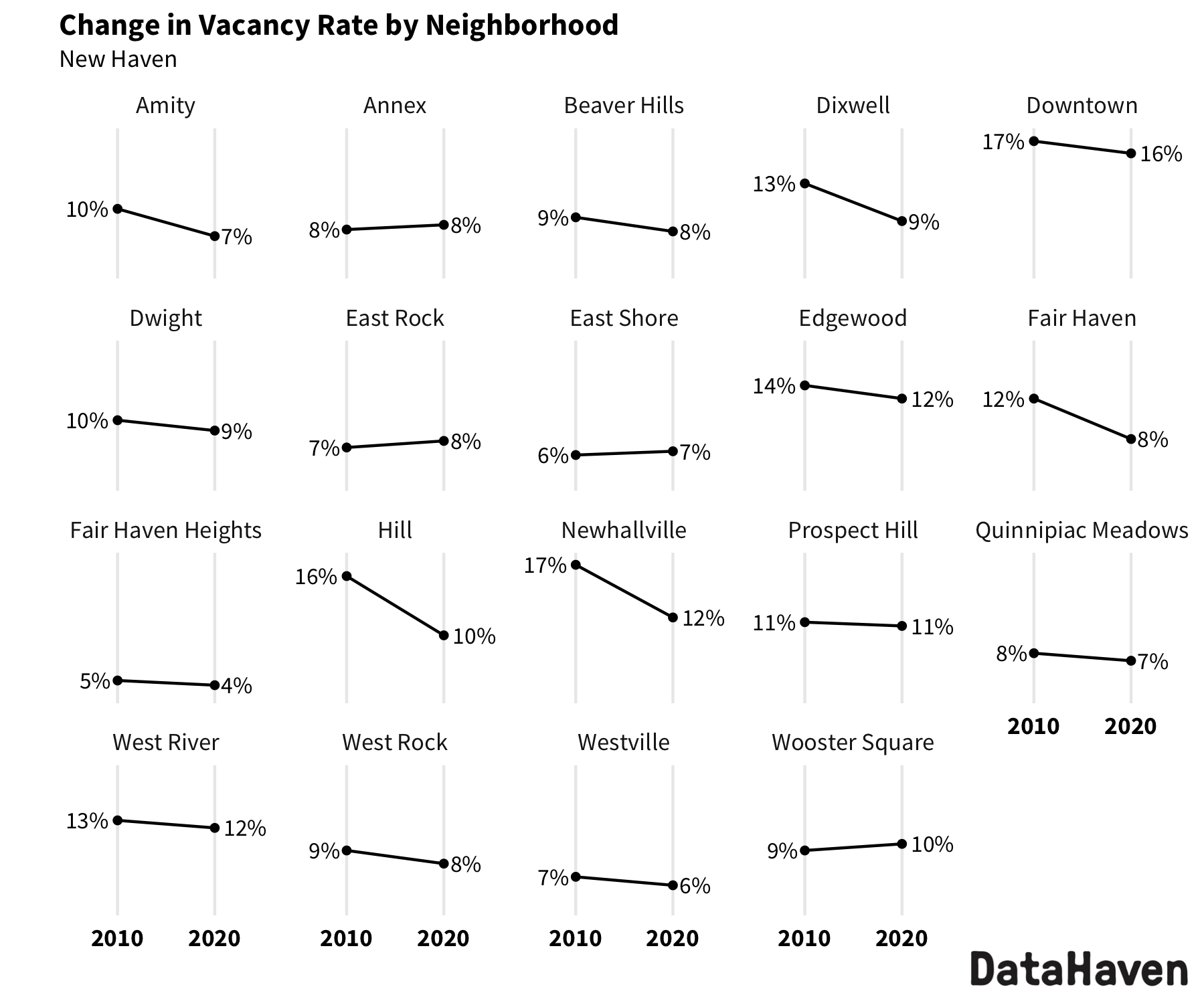
Other notable growth was measured in Newhallville, Prospect Hill, and East Rock. Population growth in Newhallville appears to be related to a drop in the neighborhood’s total vacancy rate rather than any significant new development. In 2010, 17 percent of units were vacant compared to 12 percent in 2020. The Latino population in Newhallville more than doubled, from 606 to 1,451.
New housing units concentrated in few neighborhoods
Growth in Prospect Hill could be partly related to the opening of Winchester Lofts. In East Rock, the 393 new units in the neighborhood include large developments such as the Corsair, which contributed to population growth.
The Annex, Dixwell, Edgewood, and Quinnipiac Meadows showed no significant change in their population, while the remaining neighborhoods measured moderate population changes. Despite losing a small share of its population with the closure of Church Street South, the Hill remains the most populous neighborhood in New Haven, followed by Fair Haven and Downtown. Wooster Square lost a greater share of population than most neighborhoods, due to the partial closure of Farnam Courts.
The city added 2,556 new housing units in the past decade, but more than half of those were located in just two neighborhoods: Downtown and East Rock. The city and state continue to grapple with affordable housing challenges that are compounded by a lack of development.
The city’s total housing vacancy rate dropped from 11 percent in 2010 to 9 percent in 2020. As of the 2020 Census, vacancy rates were highest Downtown (16 percent) and lowest in Fair Haven Heights (4 percent). However, local-level housing vacancy rates shift continuously due to a range of factors including renovations and the leasing up of new apartment buildings.
Racial and ethnic diversity underlies growth
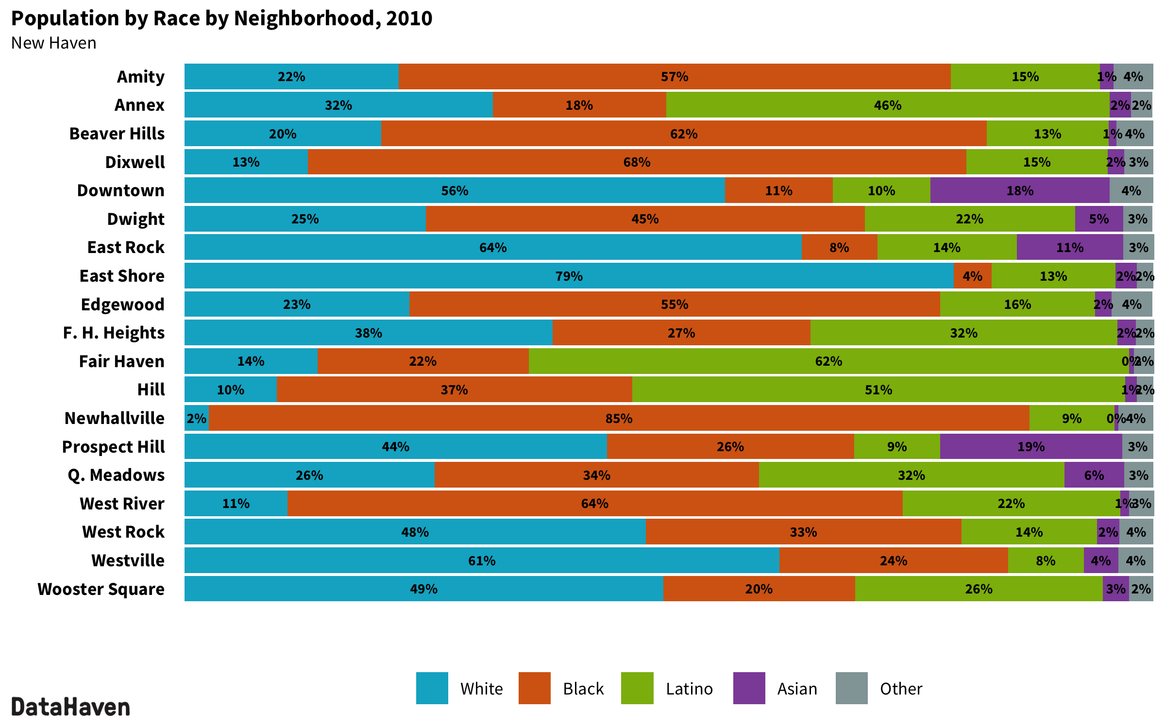
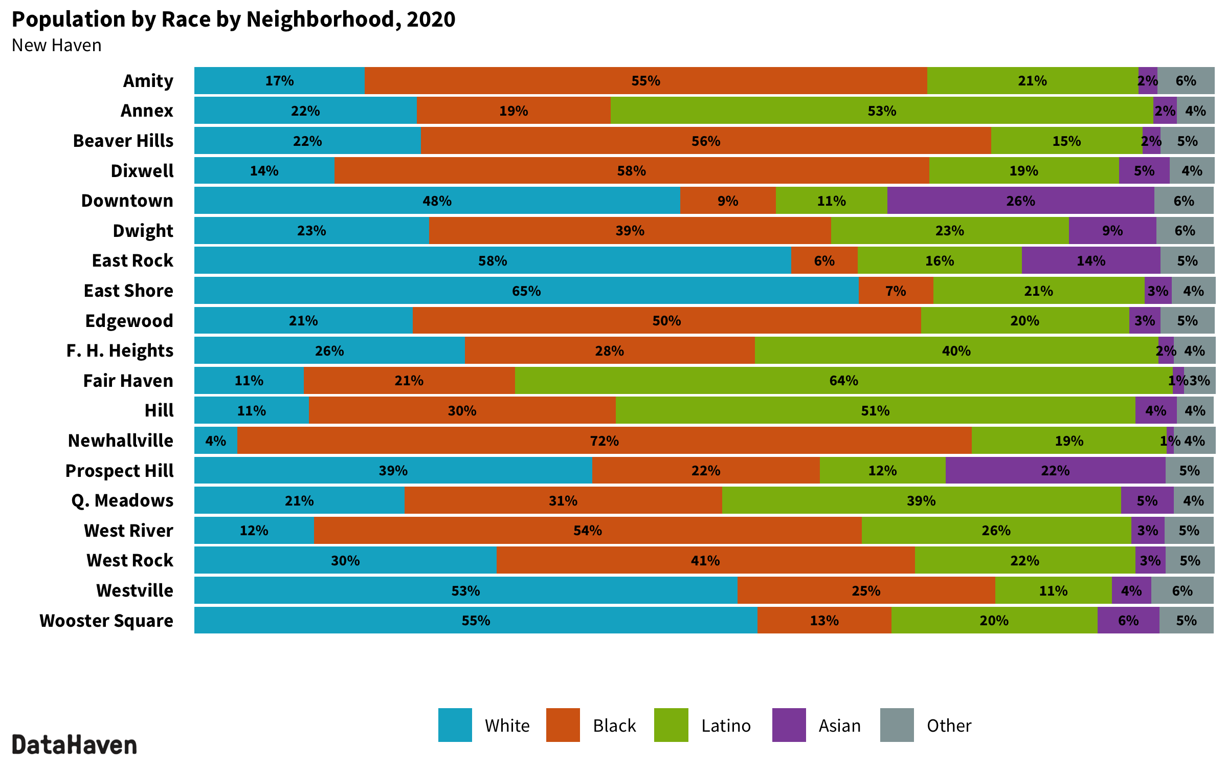
Between 2010 and 2020, the Latino population increased in almost every neighborhood, declining only in Wooster Square. Black and white populations declined in most neighborhoods, due in part to young people identifying as more than one race alone. The Asian population increased considerably in several neighborhoods, most notably Downtown.
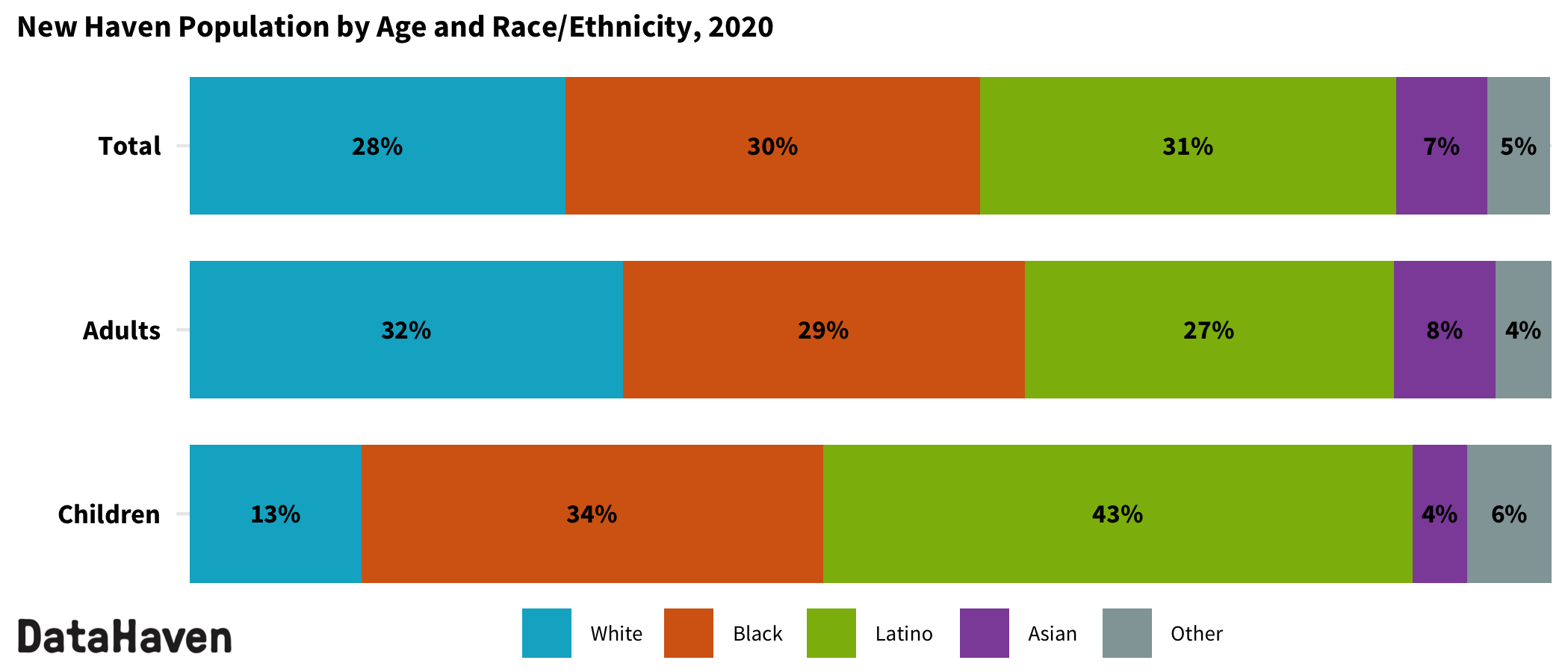
According to the new data, New Haven’s children are less likely to identify as white than the city’s adults. Among children, 13 percent identify as white, 34 percent as Black, 43 percent as Latino, 4 percent as Asian, and 6 percent another race/ethnicity or multiracial.
Among adults, 32 percent identify as white, 29 percent as Black, 27 percent as Latino, 8 percent as Asian, and 4 percent another race/ethnicity or multiracial.
Despite the city’s overall racial diversity, several neighborhoods still record a majority racial or ethnic group—a group that comprises at least half of the neighborhood’s population. Currently, there are four majority white neighborhoods (East Rock, the East Shore, Westville, and Wooster Square); six majority-Black neighborhoods (Amity, Beaver Hills, Dixwell, Edgewood, Newhallville, and West River); and three majority-Latino neighborhoods (the Annex, Fair Haven, and the Hill).
The remaining six neighborhoods have no majority racial or ethnic group. Notably, Downtown was a majority-white neighborhood in 2010 but no longer has one majority racial group.
New Haven’s Complete Count Committee—including residents and organizations who worked tirelessly to ensure a fair and accurate count of the city’s residents—was encouraged by the release of 2020 Census results. These data will be used for redistricting and drawing new wards for New Haven.
As the Census Bureau releases even more detailed information in the coming months, DataHaven and other researchers will develop a deeper understanding of the reasons behind the changes noted here. These data are instrumental for our democracy—not only for creating representative voting districts and guiding the distribution of billions of dollars in federal funding, but also for planning education, housing, and health services and ensuring equitable investment in all of our communities.
Note: A version of this report was published in the New Haven Independent on August 19, 2021, under the title “Over decade, neighborhoods change.” The above report updates that publication. Numbers may have changed slightly as the result of a refined methodology that better utilizes Census geographies for more accurate counts. Also, notably, where Southern Connecticut State University was fully counted within West Rock in the previous publication, this report splits the campus between West Rock and Beaver Hills to better align with Census geographies and ensure consistency with how neighborhood data has historically been reported.


